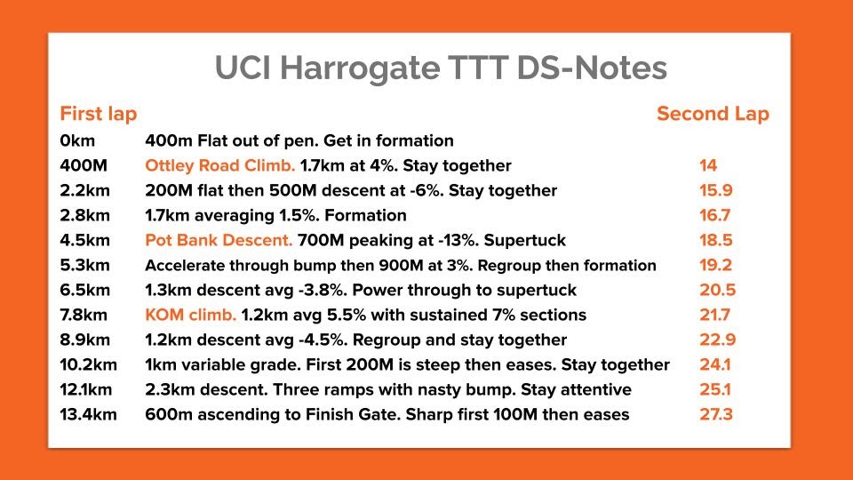
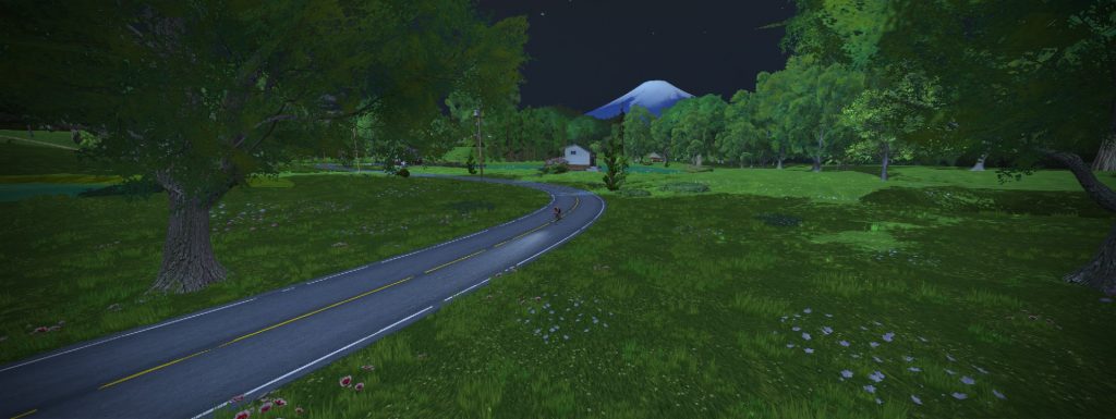
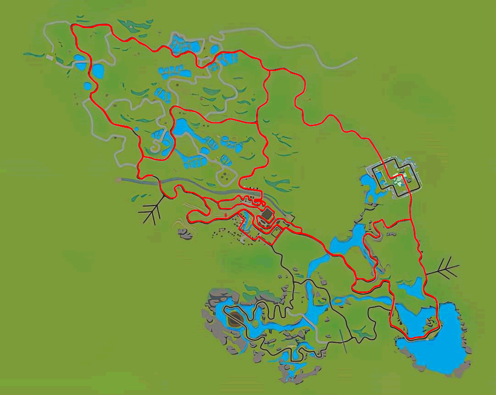
This page includes basic details for all routes on Zwift’s Makuri Islands world. For additional route details, click the corresponding link to be taken to that route’s detail page.

This scenic loop is on Urukazi’s largest island, home to the giant stone shisa who watch over all of Urukazi. The hilly circuit surrounds Festival Harbor, a colorful ocean harbor complete with statues, kites, homes, and beautiful flora/fauna.
Route Basics
Length: 6.2 km (3.9 miles)
Elevation: 60 m (197‘)
Lead-In: 1.9 km (1.2 miles)
Map: Makuri Islands
Restriction: none
Achievement Badge: 125 XP
This scenic loop is on Urukazi’s largest island, home to the giant stone shisa who watch over all of Urukazi. The hilly circuit surrounds Festival Harbor, a colorful ocean harbor complete with statues, kites, homes, and beautiful flora/fauna.

Originally created as a Rebel Route in November of 2021, Castle Crit is the brainchild of Zwifter Anders Fougner. It’s the pitchy, country counterpoint to the flatter, urban Neokyo Crit Course.
We used Anders’ idea but changed the direction of the circuit so it would end with a short flat section after the key climb and give riders a short descent after the sprint segment.
This route was added to the Zwift canon in January 2024 to host the final stage of Tour de Zwift 2024.
Route Basics
Length: 3.5 km (2.2 miles)
Elevation: 44 m (144‘)
Lead-In: 1.5 km (0.9 miles)
Map: Makuri Islands
Restriction: none
Achievement Badge: 69 XP
Originally created as a Rebel Route in November of 2021, Castle Crit is the brainchild of Zwifter Anders Fougner. It’s the pitchy, country counterpoint to the flatter, urban Neokyo Crit Course.
We used Anders’ idea but changed the direction of the circuit so it would end with a short flat section after the key climb and give riders a short descent after the sprint segment.
This route was added to the Zwift canon in January 2024 to host the final stage of Tour de Zwift 2024.

Route Basics
Length: km ( miles)
Elevation: m (‘)
Lead-In: km ( miles)
Map:
Restriction:

Released in Zwift’s January 2022 update, Castle to Castle draws its name from the two castles you’ll pass along the way – first the castle area in Yumezi, then the imperial palace in the Neokyo’s Castle Park.
Route Basics
Length: 22.4 km (13.9 miles)
Elevation: 140 m (459‘)
Lead-In: 0.8 km (0.5 miles)
Map: Makuri Islands
Restriction: none
Achievement Badge: 460 XP
Released in Zwift’s January 2022 update, Castle to Castle draws its name from the two castles you’ll pass along the way – first the castle area in Yumezi, then the imperial palace in the Neokyo’s Castle Park.

Introduced in Zwift’s May 2021 Yumezi launch, Chain Chomper is one of the tougher routes on this map. It takes you up the Castle and Temple KOMs in back-to-back fashion, then you descend to finish at the Country Sprint.
Route Basics
Length: 13.6 km (8.5 miles)
Elevation: 184 m (604‘)
Lead-In: 2.3 km (1.4 miles)
Map: Makuri Islands
Restriction: none
Achievement Badge: 270 XP
Introduced in Zwift’s May 2021 Yumezi launch, Chain Chomper is one of the tougher routes on this map. It takes you up the Castle and Temple KOMs in back-to-back fashion, then you descend to finish at the Country Sprint.

Released in Zwift’s February 2022 update, Chasing the Sun was the longest route on Makuri Islands until Makuri 40 was released. With contrasting portions based in Neokyo and Yumezi, it includes three sprint segments and two climbs, only one of which is a timed segment.
Route Basics
Length: 35.1 km (21.8 miles)
Elevation: 316 m (1,037‘)
Lead-In: 0 km ( miles)
Map: Makuri Islands
Restriction: none
Achievement Badge: 690 XP
Released in Zwift’s February 2022 update, Chasing the Sun was the longest route on Makuri Islands until Makuri 40 was released. With contrasting portions based in Neokyo and Yumezi, it includes three sprint segments and two climbs, only one of which is a timed segment.

One of Makuri Islands’ longest routes, Country to Coastal takes you on a tour of Yumezi’s castle area and farmlands as well as Urukazi’s wild coastline. This is the only existing route which takes you down the slot canyon connector road… then back up that same road!
Route Basics
Length: 33.4 km (20.8 miles)
Elevation: 275 m (902‘)
Lead-In: 0.1 km (0.1 miles)
Map: Makuri Islands
Restriction: none
Achievement Badge: 665 XP
One of Makuri Islands’ longest routes, Country to Coastal takes you on a tour of Yumezi’s castle area and farmlands as well as Urukazi’s wild coastline. This is the only existing route which takes you down the slot canyon connector road… then back up that same road!

Introduced in Zwift’s May 2021 Yumezi launch, Countryside Tour is sort of a reverse Chain Chomper with some extra flat road at the beginning.
Route Basics
Length: 16 km (9.9 miles)
Elevation: 185 m (607‘)
Lead-In: 0.2 km (0.1 miles)
Map: Makuri Islands
Restriction: none
Achievement Badge: 310 XP
Introduced in Zwift’s May 2021 Yumezi launch, Countryside Tour is sort of a reverse Chain Chomper with some extra flat road at the beginning.

Released in October 2025 to host Zwift Unlocked events, Electric Break keeps riders in Neokyo, apart from a little out and back through Pain Cavern…
Route Basics
Length: 17.8 km (11.1 miles)
Elevation: 190 m (623‘)
Lead-In: 1.8 km (1.1 miles)
Map: Makuri Islands
Restriction: none
Achievement Badge: 355 XP
Released in October 2025 to host Zwift Unlocked events, Electric Break keeps riders in Neokyo, apart from a little out and back through Pain Cavern…

Released in Zwift’s February 2022 update, Electric Loop is a flat, short circuit similar to Twilight Harbor, but in the opposite direction.
Route Basics
Length: 8.9 km (5.5 miles)
Elevation: 43 m (141‘)
Lead-In: 0 km ( miles)
Map: Makuri Islands
Restriction: none
Achievement Badge: 170 XP
Released in Zwift’s February 2022 update, Electric Loop is a flat, short circuit similar to Twilight Harbor, but in the opposite direction.

Launched in Zwift’s August 2021 update, Farmland Loop is the second-flattest route on the Makuri Islands map at the time of its launch.
Route Basics
Length: 7.9 km (4.9 miles)
Elevation: 58 m (190‘)
Lead-In: 0.2 km (0.1 miles)
Map: Makuri Islands
Restriction: none
Achievement Badge: 155 XP
Launched in Zwift’s August 2021 update, Farmland Loop is the second-flattest route on the Makuri Islands map at the time of its launch.

Sort of the little brother to Island Outskirts, Fine and Sandy is a shorter figure 8 of the Urukazi island complex which includes two efforts up the Mech Isle dirt climb.
Route Basics
Length: 10.6 km (6.6 miles)
Elevation: 77 m (253‘)
Lead-In: 0.1 km (0.1 miles)
Map: Makuri Islands
Restriction: none
Achievement Badge: 210 XP
Sort of the little brother to Island Outskirts, Fine and Sandy is a shorter figure 8 of the Urukazi island complex which includes two efforts up the Mech Isle dirt climb.

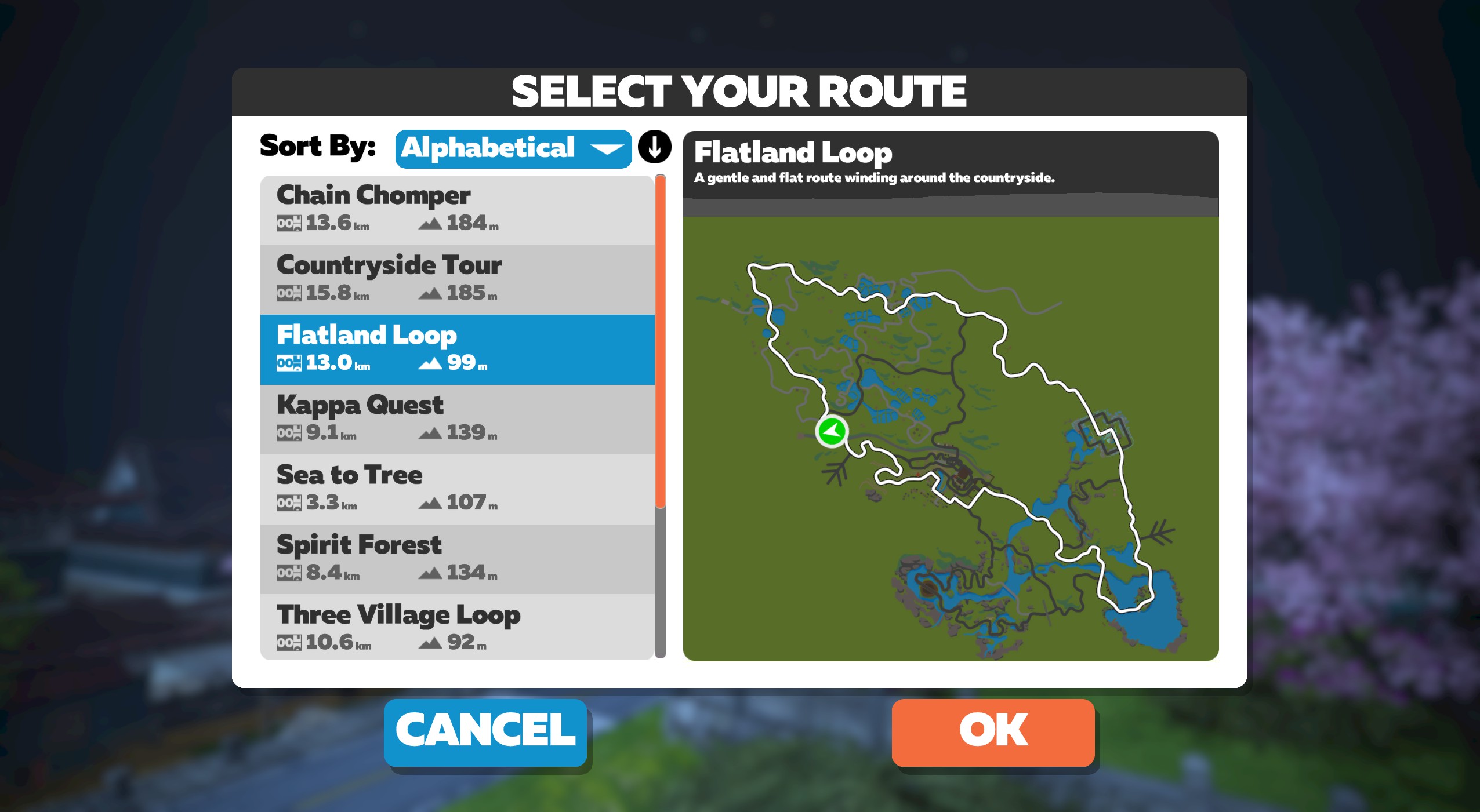
Introduced in Zwift’s May 2021 Yumezi launch, Flatland Loop contains a few more lumps and bumps than the name implies – in fact, it’s not even the flattest route on the Yumezi map (that distinction goes to Two Village Loop)! But it does manage to skip the KOMs.
Route Basics
Length: 12.9 km (8.0 miles)
Elevation: 96 m (315‘)
Lead-In: 0.2 km (0.1 miles)
Map: Makuri Islands
Restriction: none
Achievement Badge: 260 XP
Introduced in Zwift’s May 2021 Yumezi launch, Flatland Loop contains a few more lumps and bumps than the name implies – in fact, it’s not even the flattest route on the Yumezi map (that distinction goes to Two Village Loop)! But it does manage to skip the KOMs.

Looking for the full Urukazi tour? The Island Hopper covers all Urukazi roads (except for the connector roads to Neokyo and Yumezi). This route takes you on two loops of the Urukazi island complex. Your first loop takes the innermost roads on each of the islands, while the second loop takes the outermost roads.
Route Basics
Length: 18 km (11.2 miles)
Elevation: 129 m (423‘)
Lead-In: 0.1 km (0.1 miles)
Map: Makuri Islands
Restriction: none
Achievement Badge: 360 XP
Looking for the full Urukazi tour? The Island Hopper covers all Urukazi roads (except for the connector roads to Neokyo and Yumezi). This route takes you on two loops of the Urukazi island complex. Your first loop takes the innermost roads on each of the islands, while the second loop takes the outermost roads.

Taking in (almost) all of Urukazi’s outermost roads, this loop gives you a tour of the island group, taking you to the highest point on the map along the way.
Route Basics
Length: 11.4 km (7.1 miles)
Elevation: 90 m (295‘)
Lead-In: 0.1 km (0.1 miles)
Map: Makuri Islands
Restriction: none
Achievement Badge: 225 XP
Taking in (almost) all of Urukazi’s outermost roads, this loop gives you a tour of the island group, taking you to the highest point on the map along the way.

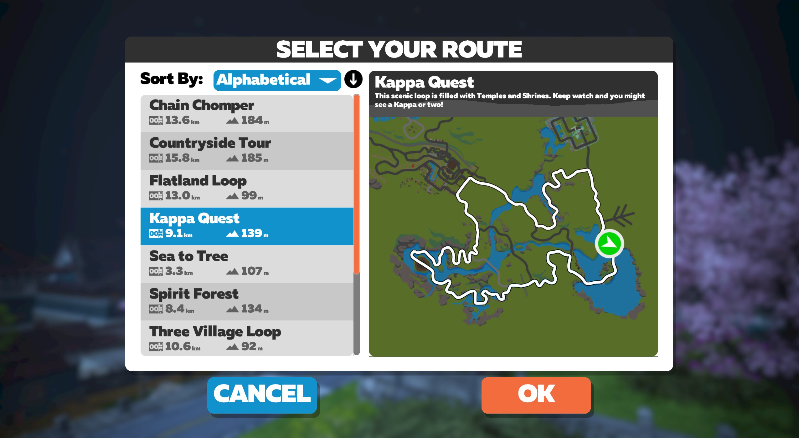
Introduced in Zwift’s May 2021 Yumezi launch, Kappa Quest is named after the amphibious yōkai demon/imp found in Japanese folklore. Keep your eyes open – perhaps you’ll see one?
Route Basics
Length: 9.1 km (5.7 miles)
Elevation: 140 m (459‘)
Lead-In: 3.8 km (2.4 miles)
Map: Makuri Islands
Restriction: none
Achievement Badge: 180 XP
Introduced in Zwift’s May 2021 Yumezi launch, Kappa Quest is named after the amphibious yōkai demon/imp found in Japanese folklore. Keep your eyes open – perhaps you’ll see one?

Introduced two months after Yumezi’s launch, Kappa Quest Reverse is simply the reverse version of Kappa Quest.
Route Basics
Length: 9 km (5.6 miles)
Elevation: 139 m (456‘)
Lead-In: 5.1 km (3.2 miles)
Map: Makuri Islands
Restriction: none
Achievement Badge: 180 XP
Introduced two months after Yumezi’s launch, Kappa Quest Reverse is simply the reverse version of Kappa Quest.

Launching with Zwift Games 2026, this route loops the well-known Pain Cavern>Neokyo>Slot Canyon>Urukazi circuit, but finishes with a spicy little spur on the Boardwalk.
Route Basics
Length: 16.9 km (10.5 miles)
Elevation: 134 m (440‘)
Lead-In: 0.4 km (0.2 miles)
Map: Makuri Islands
Restriction: none
Achievement Badge: 340 XP
Launching with Zwift Games 2026, this route loops the well-known Pain Cavern>Neokyo>Slot Canyon>Urukazi circuit, but finishes with a spicy little spur on the Boardwalk.

The longest route in Makuri Islands when it launched in November 2022, Makuri 40 covers major parts of all three sections: Yumezi, Neokyo, and Urukazi.
Route Basics
Length: 40.2 km (25.0 miles)
Elevation: 308 m (1,010‘)
Lead-In: 0.1 km (0.1 miles)
Map: Makuri Islands
Restriction: none
Achievement Badge: 800 XP
The longest route in Makuri Islands when it launched in November 2022, Makuri 40 covers major parts of all three sections: Yumezi, Neokyo, and Urukazi.

Released for Zwift Games 2025, Makuri Madness is a mostly-flat route with a single short, sharp climb.
Route Basics
Length: 15.9 km (9.9 miles)
Elevation: 85 m (279‘)
Lead-In: 0.1 km (0.1 miles)
Map: Makuri Islands
Restriction: none
Achievement Badge: 325 XP
Released for Zwift Games 2025, Makuri Madness is a mostly-flat route with a single short, sharp climb.

Far and away the longest Makuri Islands route when it was released in September 2024, Makuri Pretzel covers key roads in each of the three Makuri Islands areas: Yumezi, Neokyo, and Urukazi. And it covers them in both directions, which means you hit four different sprint arches in both directions for a total of eight sprint opportunities.
This route is the brainchild of James Bailey, Zwift’s event guru. While it avoids all the Makuri Islands KOM segments, you’ll want to keep your eyes open in a race. There are plenty of sneaky, draggy climbs that provide ample opportunity for attacks.
Route Basics
Length: 77.6 km (48.2 miles)
Elevation: 616 m (2,021‘)
Lead-In: 1.1 km (0.7 miles)
Map: Makuri Islands
Restriction: none
Achievement Badge: 1550 XP
Far and away the longest Makuri Islands route when it was released in September 2024, Makuri Pretzel covers key roads in each of the three Makuri Islands areas: Yumezi, Neokyo, and Urukazi. And it covers them in both directions, which means you hit four different sprint arches in both directions for a total of eight sprint opportunities.
This route is the brainchild of James Bailey, Zwift’s event guru. While it avoids all the Makuri Islands KOM segments, you’ll want to keep your eyes open in a race. There are plenty of sneaky, draggy climbs that provide ample opportunity for attacks.

The shortest route in the Urukazi map, Mech Isle Loop takes you on a quick circuit of Mech Isle. What do they do here, anyway? It’s all a bit hush-hush, but the gigantic robo-parts seen here and there would indicate that the island lives up to its name.
Route Basics
Length: 4 km (2.5 miles)
Elevation: 39 m (128‘)
Lead-In: 0.1 km (0.1 miles)
Map: Makuri Islands
Restriction: none
Achievement Badge: 80 XP
The shortest route in the Urukazi map, Mech Isle Loop takes you on a quick circuit of Mech Isle. What do they do here, anyway? It’s all a bit hush-hush, but the gigantic robo-parts seen here and there would indicate that the island lives up to its name.

Introduced in Zwift’s November 2021 update, Neokyo All-Nighter is the longest “Neokyo-only” route upon its release. At nearly 25km in length, this route covers nearly every bit of road in Neokyo, including 4 sprint segments and the Rooftop KOM.
Route Basics
Length: 24.3 km (15.1 miles)
Elevation: 168 m (551‘)
Lead-In: 0.2 km (0.1 miles)
Map: Makuri Islands
Restriction: none
Achievement Badge: 485 XP
Introduced in Zwift’s November 2021 update, Neokyo All-Nighter is the longest “Neokyo-only” route upon its release. At nearly 25km in length, this route covers nearly every bit of road in Neokyo, including 4 sprint segments and the Rooftop KOM.

Released unannounced in Zwift’s November 2021 update, Neokyo Crit Course is an event-only route which would have slipped under the radar except that its route badge appears in game. That’s right – a route badge for an event-only route! (A first on Zwift.)
Route Basics
Length: 3.9 km (2.4 miles)
Elevation: 19 m (62‘)
Lead-In: 0.7 km (0.4 miles)
Map: Makuri Islands
Restriction: Event Only
Achievement Badge: 90 XP
Released unannounced in Zwift’s November 2021 update, Neokyo Crit Course is an event-only route which would have slipped under the radar except that its route badge appears in game. That’s right – a route badge for an event-only route! (A first on Zwift.)

Introduced in Zwift’s November 2021 update, Neon Flats is one of the flattest Neokyo routes around. (Oddly enough, it’s not the flattest – that award goes to Sleepless City.) This is a great route if you’re looking for something flat and fast, with sprint segments to contest.
Route Basics
Length: 14.7 km (9.1 miles)
Elevation: 73 m (240‘)
Lead-In: 0.2 km (0.1 miles)
Map: Makuri Islands
Restriction: none
Achievement Badge: 290 XP
Introduced in Zwift’s November 2021 update, Neon Flats is one of the flattest Neokyo routes around. (Oddly enough, it’s not the flattest – that award goes to Sleepless City.) This is a great route if you’re looking for something flat and fast, with sprint segments to contest.

Created to host team time trials for the first race of ZRL’s 2025/26 Round 3, Neon Shore Loop begins with a tour through most of Neokyo before looping out to the islands of Urukazi. It’s a mostly flat route, with a few key climbs to test teams’ cohesiveness and pacing.
Route Basics
Length: 32.9 km (20.4 miles)
Elevation: 215 m (705‘)
Lead-In: 1.1 km (0.7 miles)
Map: Makuri Islands
Restriction: Event Only
Achievement Badge: 660 XP
Created to host team time trials for the first race of ZRL’s 2025/26 Round 3, Neon Shore Loop begins with a tour through most of Neokyo before looping out to the islands of Urukazi. It’s a mostly flat route, with a few key climbs to test teams’ cohesiveness and pacing.

Introduced in Zwift’s November 2021 update, Railways and Rooftops is almost the pitchiest route in Neokyo, climbing 70 meters over its 6.2km length. Along the way it takes you over the Railway Sprint then up the backside of the Rooftop KOM which (strangely) is not currently a timed segment.
Route Basics
Length: 6.2 km (3.9 miles)
Elevation: 71 m (233‘)
Lead-In: 2.1 km (1.3 miles)
Map: Makuri Islands
Restriction: none
Achievement Badge: 120 XP
Introduced in Zwift’s November 2021 update, Railways and Rooftops is almost the pitchiest route in Neokyo, climbing 70 meters over its 6.2km length. Along the way it takes you over the Railway Sprint then up the backside of the Rooftop KOM which (strangely) is not currently a timed segment.

Added to the game in August 2025 as an event-only route to host events for Zwift Camp: Baseline, Red Zone Repeats begins with a flat lead-in from the Yumezi countryside, then heads to Neokyo for three laps of a flat circuit before ending in a Tower Sprint finish.
Route Basics
Length: 19.4 km (12.1 miles)
Elevation: 87 m (285‘)
Lead-In: 0.2 km (0.1 miles)
Map: Makuri Islands
Restriction: none
Achievement Badge: 390 XP
Added to the game in August 2025 as an event-only route to host events for Zwift Camp: Baseline, Red Zone Repeats begins with a flat lead-in from the Yumezi countryside, then heads to Neokyo for three laps of a flat circuit before ending in a Tower Sprint finish.

Introduced in Zwift’s November 2021 update, Rooftop Rendezvous is Neokyo’s climbiest route. It’s a circuit that simply takes you up the Rooftop KOM then down, climbing 56 meters in each 3.7km lap.
Route Basics
Length: 3.7 km (2.3 miles)
Elevation: 56 m (184‘)
Lead-In: 2.9 km (1.8 miles)
Map: Makuri Islands
Restriction: none
Achievement Badge: 74 XP
Introduced in Zwift’s November 2021 update, Rooftop Rendezvous is Neokyo’s climbiest route. It’s a circuit that simply takes you up the Rooftop KOM then down, climbing 56 meters in each 3.7km lap.

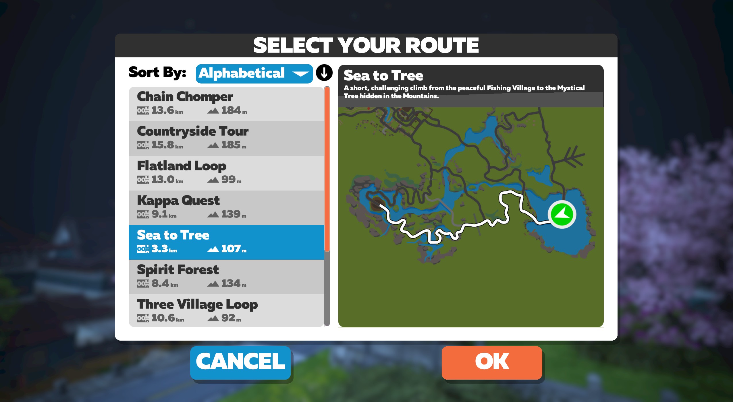
Introduced in Zwift’s May 2021 Yumezi launch, Sea to Tree is a short, one-way route up the Temple KOM from the Fishing Village side. You begin at the “sea” on the island before the Fishing Village, and end at the giant mythical tree atop the KOM.
Route Basics
Length: 3.2 km (2.0 miles)
Elevation: 106 m (348‘)
Lead-In: 0.6 km (0.4 miles)
Map: Makuri Islands
Restriction: none
Achievement Badge: 65 XP
Introduced in Zwift’s May 2021 Yumezi launch, Sea to Tree is a short, one-way route up the Temple KOM from the Fishing Village side. You begin at the “sea” on the island before the Fishing Village, and end at the giant mythical tree atop the KOM.

Introduced in Zwift’s November 2021 update, Sleepless City is the flattest route in Neokyo.
Route Basics
Length: 9.6 km (6.0 miles)
Elevation: 43 m (141‘)
Lead-In: 0 km ( miles)
Map: Makuri Islands
Restriction: none
Achievement Badge: 185 XP
Introduced in Zwift’s November 2021 update, Sleepless City is the flattest route in Neokyo.

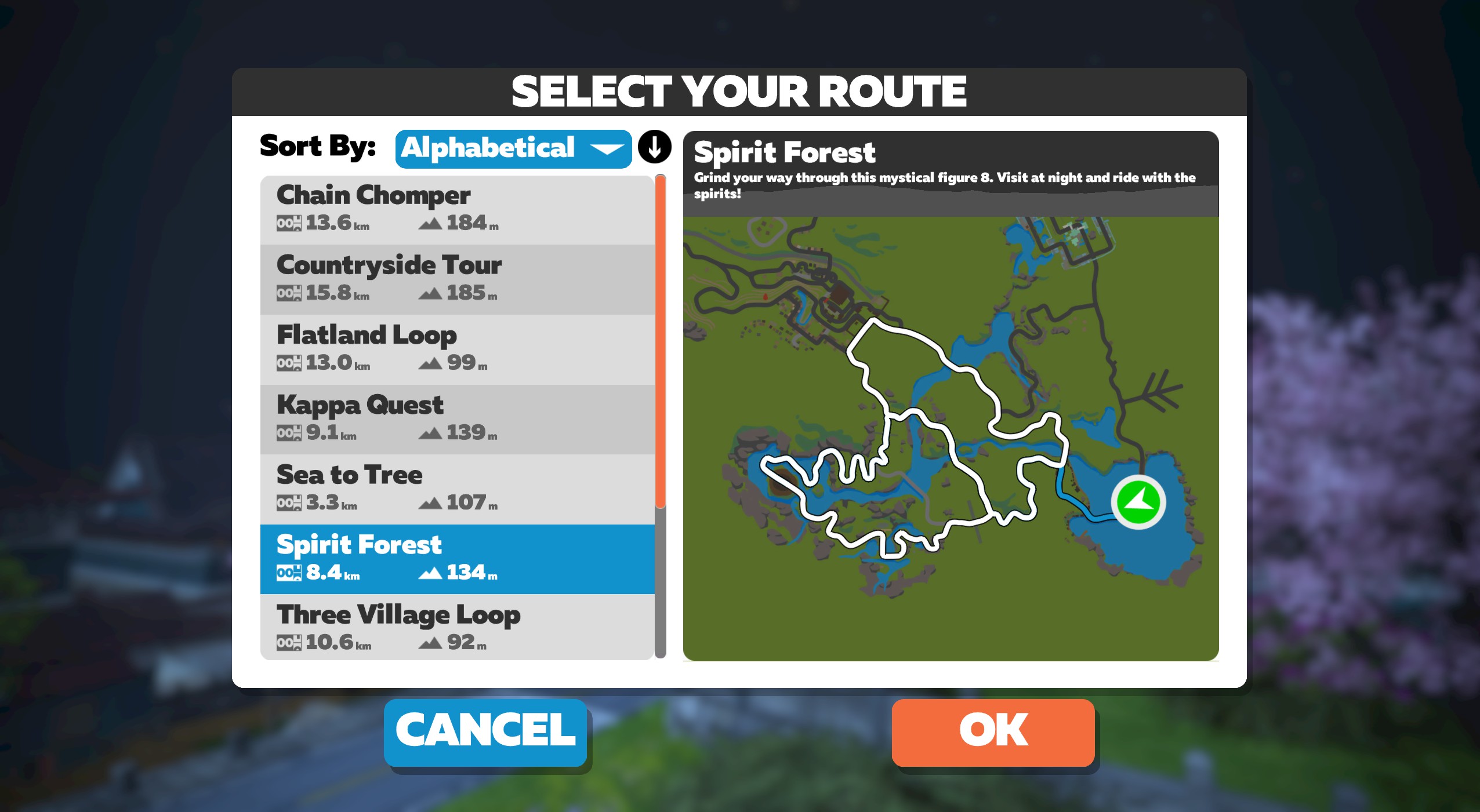
Introduced in Zwift’s May 2021 Yumezi launch, Spirit Forest is a figure 8 route that keeps you in the Temple KOM area, without actually completing any KOMs!
Route Basics
Length: 8.4 km (5.2 miles)
Elevation: 135 m (443‘)
Lead-In: 4.6 km (2.9 miles)
Map: Makuri Islands
Restriction: none
Achievement Badge: 170 XP
Introduced in Zwift’s May 2021 Yumezi launch, Spirit Forest is a figure 8 route that keeps you in the Temple KOM area, without actually completing any KOMs!

Introduced in Zwift’s November 2021 update, Sprinter’s Playground lives up to its name, taking riders over all four Neokyo sprint sections in one short, fairly flat lap.
Route Basics
Length: 12.4 km (7.7 miles)
Elevation: 68 m (223‘)
Lead-In: 0.2 km (0.1 miles)
Map: Makuri Islands
Restriction: none
Achievement Badge: 245 XP
Introduced in Zwift’s November 2021 update, Sprinter’s Playground lives up to its name, taking riders over all four Neokyo sprint sections in one short, fairly flat lap.

Introduced two months after Yumezi’s launch, Suki’s Playground is a figure 8 named in memory of Zwift Senior Game Designer Richard Yeh’s dog Suki, who passed while Richard was developing routes for the Yumezi map.
“I adopted Suki when she was only 11 weeks old, and we had a wonderful 11 years together,” says Richard. “She passed away suddenly last September, but her spirit is always still with me. She loved to run and do zoomies when she got excited. The route was initially called ‘Zoomies for Suki’, but we changed it to ‘Suki’s Playground.’”
Route Basics
Length: 18.3 km (11.4 miles)
Elevation: 150 m (492‘)
Lead-In: 0.2 km (0.1 miles)
Map: Makuri Islands
Restriction: none
Achievement Badge: 365 XP
Introduced two months after Yumezi’s launch, Suki’s Playground is a figure 8 named in memory of Zwift Senior Game Designer Richard Yeh’s dog Suki, who passed while Richard was developing routes for the Yumezi map.
“I adopted Suki when she was only 11 weeks old, and we had a wonderful 11 years together,” says Richard. “She passed away suddenly last September, but her spirit is always still with me. She loved to run and do zoomies when she got excited. The route was initially called ‘Zoomies for Suki’, but we changed it to ‘Suki’s Playground.’”

When it was introduced in Zwift’s November 2021 update, Temples and Towers was the biggest Makuri Islands route, both in elevation and distance. It no longer holds that title, but it still takes you up all three KOMs: Rooftop, Castle, and Temple.
Route Basics
Length: 32.6 km (20.3 miles)
Elevation: 319 m (1,047‘)
Lead-In: 0.7 km (0.4 miles)
Map: Makuri Islands
Restriction: none
Achievement Badge: 650 XP
When it was introduced in Zwift’s November 2021 update, Temples and Towers was the biggest Makuri Islands route, both in elevation and distance. It no longer holds that title, but it still takes you up all three KOMs: Rooftop, Castle, and Temple.

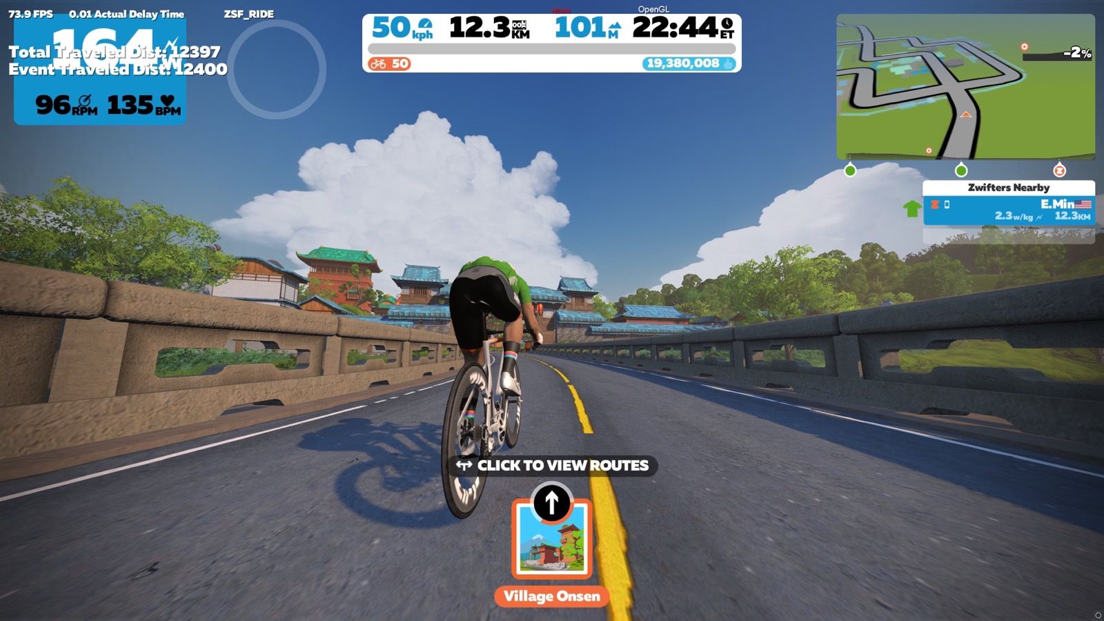
Introduced in Zwift’s May 2021 Yumezi launch, Three Village Loop takes you on the shortest possible route between the three villages of the Yumezi map: the Castle, Fishing Village, and Village Onsen.
Route Basics
Length: 10.6 km (6.6 miles)
Elevation: 93 m (305‘)
Lead-In: 2.3 km (1.4 miles)
Map: Makuri Islands
Restriction: none
Achievement Badge: 210 XP
Introduced in Zwift’s May 2021 Yumezi launch, Three Village Loop takes you on the shortest possible route between the three villages of the Yumezi map: the Castle, Fishing Village, and Village Onsen.

Released in October 2025 to host Zwift Unlocked events, Tropic Rush is similar to Turf N Surf, but with a longer flat start and a spicy extra climb near the end! Read on for details…
Route Basics
Length: 41.2 km (25.6 miles)
Elevation: 328 m (1,076‘)
Lead-In: 1.6 km (1.0 miles)
Map: Makuri Islands
Restriction: none
Achievement Badge: 825 XP
Released in October 2025 to host Zwift Unlocked events, Tropic Rush is similar to Turf N Surf, but with a longer flat start and a spicy extra climb near the end! Read on for details…

Ride through Neokyo’s urban permanight, then make your way through the slot canyon to Urukazi’s wild coastline before returning to Neokyo via the cavern road.
Route Basics
Length: 24.6 km (15.3 miles)
Elevation: 196 m (643‘)
Lead-In: 0.1 km (0.1 miles)
Map: Makuri Islands
Restriction: none
Achievement Badge: 490 XP
Ride through Neokyo’s urban permanight, then make your way through the slot canyon to Urukazi’s wild coastline before returning to Neokyo via the cavern road.

Released in Zwift’s January 2022 update, Twilight Harbor is a short circuit with two sprint segments, making it perfect for flat crit-style racing.
Route Basics
Length: 6.9 km (4.3 miles)
Elevation: 33 m (108‘)
Lead-In: 0.2 km (0.1 miles)
Map: Makuri Islands
Restriction: none
Achievement Badge: 135 XP
Released in Zwift’s January 2022 update, Twilight Harbor is a short circuit with two sprint segments, making it perfect for flat crit-style racing.

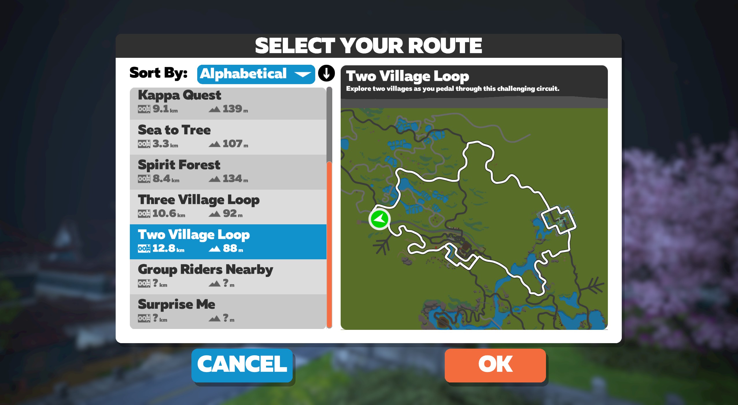
Introduced in Zwift’s May 2021 Yumezi launch, Two Village Loop was originally the flattest route on the map. It takes you around the Castle and Village Onsen (hence the name), and along the way you’ll ride some short bits of road that aren’t often ridden via official routes. Enjoy!
Route Basics
Length: 12.8 km (8.0 miles)
Elevation: 88 m (289‘)
Lead-In: 0.2 km (0.1 miles)
Map: Makuri Islands
Restriction: none
Achievement Badge: 255 XP
Introduced in Zwift’s May 2021 Yumezi launch, Two Village Loop was originally the flattest route on the map. It takes you around the Castle and Village Onsen (hence the name), and along the way you’ll ride some short bits of road that aren’t often ridden via official routes. Enjoy!

Launched in Zwift’s August 2021 update, Valley to Mountaintop is sort of the sister route of “Sea to Tree“. Both start near the Village Onsen start pens, but they each attack the Temple KOM from a different side.
Route Basics
Length: 5 km (3.1 miles)
Elevation: 129 m (423‘)
Lead-In: 0.1 km (0.1 miles)
Map: Makuri Islands
Restriction: none
Achievement Badge: 100 XP
Launched in Zwift’s August 2021 update, Valley to Mountaintop is sort of the sister route of “Sea to Tree“. Both start near the Village Onsen start pens, but they each attack the Temple KOM from a different side.

Introduced in Zwift’s November 2021 update, Wandering Flats was one of the longest Makuri Islands routes, and fairly flat, as the name implies.
Route Basics
Length: 25.1 km (15.6 miles)
Elevation: 146 m (479‘)
Lead-In: 0.1 km (0.1 miles)
Map: Makuri Islands
Restriction: none
Achievement Badge: 515 XP
Introduced in Zwift’s November 2021 update, Wandering Flats was one of the longest Makuri Islands routes, and fairly flat, as the name implies.

More info coming soon…
Route Basics
Length: 6.9 km (4.3 miles)
Elevation: 32 m (105‘)
Lead-In: 1.1 km (0.7 miles)
Map: Makuri Islands
Restriction: Run Only
More info coming soon…
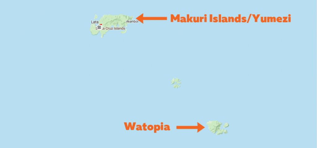
Looking for route details of other Zwift worlds? Jump to:
 Released")


")