This page includes basic details for all routes on Zwift’s New York world. For additional route details, click the corresponding link to be taken to that route’s detail page.

Released in Zwift’s December 2021 update, this route was created to host the UCI Cycling Esports Worlds in February 2022 (read more about the event).
The route is 2.5 laps of New York’s Knickerbocker route, ending atop of the KOM.
Route Basics
Length: 54.7 km (34.0 miles)
Elevation: 943 m (3,094‘)
Lead-In: 0.2 km (0.1 miles)
Map: New York
Restriction: Event Only
Released in Zwift’s December 2021 update, this route was created to host the UCI Cycling Esports Worlds in February 2022 (read more about the event).
The route is 2.5 laps of New York’s Knickerbocker route, ending atop of the KOM.

 New York’s “Astoria Line 8” is named for NYC’s first subway line. This route covers all the ground-level roads in Central Park. Created from GPS data of the actual park roads, this route accurately reproduces the Central Park ride experience.
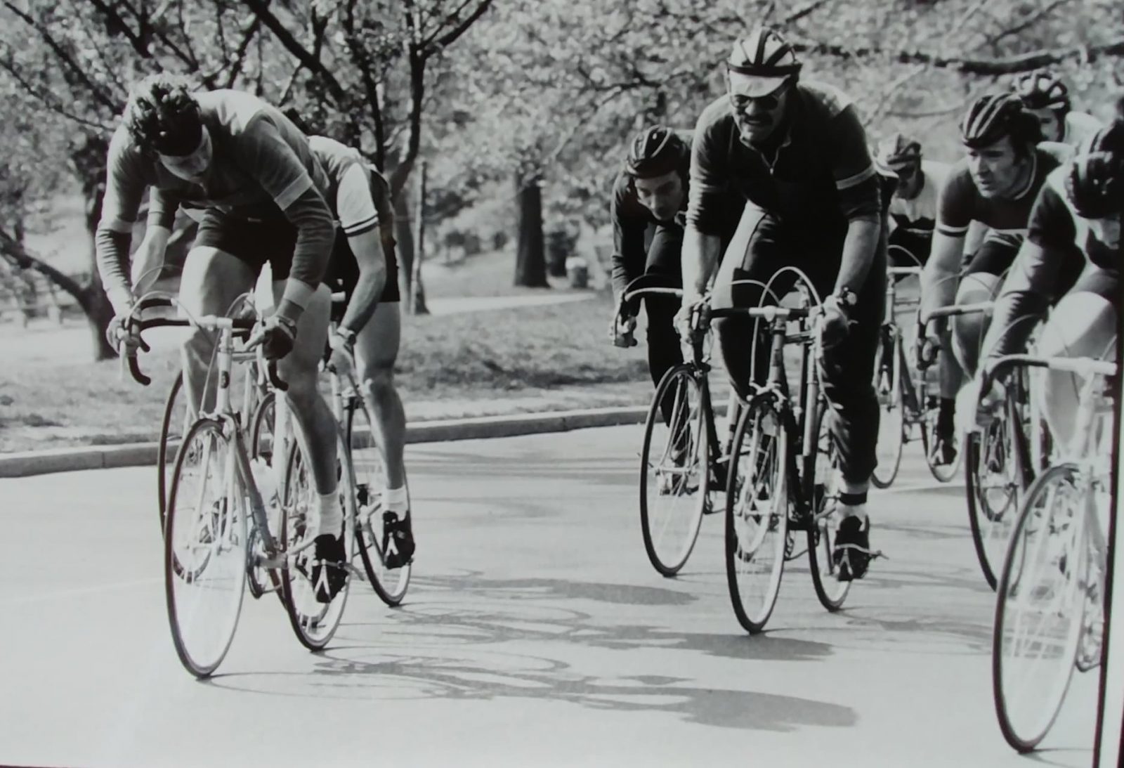
Dave Chauner (photo at right), who raced Central Park back in the late 60’s/early 70’s, had this to say after riding the roads on Zwift: Rode the new Central Park course this morning. It’s been a long time but I recognized every meter of the circuit, like this one, a mile or so from the base of Cat’s Paw Hill. But I couldn’t come close to the 13/14 minute lap times we routinely did way back when (’68, ’69, ’70, ’73) during the springtime Central Park Series. Great job Eric and the NYC boys at Zwift! (“Cat’s Paw Hill”, by the way, is the small rise leading up to the start/finish banner.)
Route Basics
Length: 11.5 km (7.1 miles)
Elevation: 140 m (459‘)
Lead-In: 0 km ( miles)
Map: New York
Restriction: none
Achievement Badge: 230 XP
New York’s “Astoria Line 8” is named for NYC’s first subway line. This route covers all the ground-level roads in Central Park. Created from GPS data of the actual park roads, this route accurately reproduces the Central Park ride experience.
Dave Chauner (photo at right), who raced Central Park back in the late 60’s/early 70’s, had this to say after riding the roads on Zwift: Rode the new Central Park course this morning. It’s been a long time but I recognized every meter of the circuit, like this one, a mile or so from the base of Cat’s Paw Hill. But I couldn’t come close to the 13/14 minute lap times we routinely did way back when (’68, ’69, ’70, ’73) during the springtime Central Park Series. Great job Eric and the NYC boys at Zwift! (“Cat’s Paw Hill”, by the way, is the small rise leading up to the start/finish banner.)

Released in October 2025 as part of the Prospect Park expansion to Zwift’s New York map, “Avon Flyer” is an homage to former Prospect Park Race Director Greg Avon, who is also a level 100 Zwifter!
Route Basics
Length: 3.3 km (2.1 miles)
Elevation: 25 m (82‘)
Lead-In: 1.8 km (1.1 miles)
Map: New York
Restriction: none
Achievement Badge: 65 XP
Released in October 2025 as part of the Prospect Park expansion to Zwift’s New York map, “Avon Flyer” is an homage to former Prospect Park Race Director Greg Avon, who is also a level 100 Zwifter!

Released in October 2025 as part of the New York map expansion, “Double Parked” does what you might expect – it takes you through both parks on the map! It feels like a fitting route, since both parks were designed by the same landscape architects, with Prospect Park a more tranquil, neighborhood-centric sister to Central Park.
Route Basics
Length: 42.2 km (26.2 miles)
Elevation: 330 m (1,083‘)
Lead-In: 0.1 km (0.1 miles)
Map: New York
Restriction: none
Achievement Badge: 845 XP
Released in October 2025 as part of the New York map expansion, “Double Parked” does what you might expect – it takes you through both parks on the map! It feels like a fitting route, since both parks were designed by the same landscape architects, with Prospect Park a more tranquil, neighborhood-centric sister to Central Park.

Released in October 2025 as part of the Prospect Park expansion to Zwift’s New York map, this route focuses on the new roads crossing the Manhattan and Brooklyn bridges. It’s a circuit that begins with a lead-in from Prospect Park, then keeps riders on the two bridges riding CCW for as many laps as you’d like!
Route Basics
Length: 7 km (4.3 miles)
Elevation: 80 m (262‘)
Lead-In: 5.6 km (3.5 miles)
Map: New York
Restriction: none
Achievement Badge: 145 XP
Released in October 2025 as part of the Prospect Park expansion to Zwift’s New York map, this route focuses on the new roads crossing the Manhattan and Brooklyn bridges. It’s a circuit that begins with a lead-in from Prospect Park, then keeps riders on the two bridges riding CCW for as many laps as you’d like!

Released in November 2025 as an event-only route to host the final race of Zwift Racing League Round 2, Empire Elevation is a one-way route that begins in Prospect Park and heads north for a spicy finish on the KOM in Central Park. It became an open route in January 2026.
Route Basics
Length: 24.2 km (15.0 miles)
Elevation: 261 m (856‘)
Lead-In: 1.8 km (1.1 miles)
Map: New York
Restriction: none
Achievement Badge: 485 XP
Released in November 2025 as an event-only route to host the final race of Zwift Racing League Round 2, Empire Elevation is a one-way route that begins in Prospect Park and heads north for a spicy finish on the KOM in Central Park. It became an open route in January 2026.

New York’s “Everything Bagel” is the longest route on the NYC course, and the perfect route for a hard ~1-hour effort. It covers nearly every road section, many of them in both directions. Looking for a challenge? You’ll get several chances to test your legs against the leaderboards as you hit the KOM and sprint sections in both directions.
Route Basics
Length: 34.8 km (21.6 miles)
Elevation: 525 m (1,722‘)
Lead-In: 0.1 km (0.1 miles)
Map: New York
Restriction: none
Achievement Badge: 690 XP
New York’s “Everything Bagel” is the longest route on the NYC course, and the perfect route for a hard ~1-hour effort. It covers nearly every road section, many of them in both directions. Looking for a challenge? You’ll get several chances to test your legs against the leaderboards as you hit the KOM and sprint sections in both directions.

First, there was Everything Bagel, the longest route in New York at just under 35km. Later, Zwift would release two event-only routes that were even longer. But in October 2025, “Fuhgeddaboudit” said “hold my martini” and came out at 79km! It’s quite a ride, covering (almost) all the roads on the map, including some in both directions!
Route Basics
Length: 79 km (49.1 miles)
Elevation: 838 m (2,749‘)
Lead-In: 0 km ( miles)
Map: New York
Restriction: none
Achievement Badge: 1595 XP
First, there was Everything Bagel, the longest route in New York at just under 35km. Later, Zwift would release two event-only routes that were even longer. But in October 2025, “Fuhgeddaboudit” said “hold my martini” and came out at 79km! It’s quite a ride, covering (almost) all the roads on the map, including some in both directions!

New York’s “Gotham Grind” was created in January 2019 as an event-only route, but became an open route in the December 2022 update.
Route Basics
Length: 9.3 km (5.8 miles)
Elevation: 96 m (315‘)
Lead-In: 0.1 km (0.1 miles)
Map: New York
Restriction:
Achievement Badge: 190 XP
New York’s “Gotham Grind” was created in January 2019 as an event-only route, but became an open route in the December 2022 update.

New York’s “Gotham Grind” was created in January 2019 and is currently only available as an event route (no free-riding).
Route Basics
Length: 9.3 km (5.8 miles)
Elevation: 96 m (315‘)
Lead-In: 0 km ( miles)
Map: New York
Restriction: Event Only
Achievement Badge: none
New York’s “Gotham Grind” was created in January 2019 and is currently only available as an event route (no free-riding).

Route Basics
Length: 6.8 km (4.2 miles)
Elevation: 144 m (472‘)
Lead-In: 1.5 km (0.9 miles)
Map: New York
Restriction: none
Achievement Badge: 140 XP

Route Basics
Length: 6.8 km (4.2 miles)
Elevation: 144 m (472‘)
Lead-In: 2.4 km (1.5 miles)
Map: New York
Restriction: Event Only
Achievement Badge: none

Released in October 2025 as part of the New York map expansion, “Green to Screen” takes riders on a tour of most of the expansion’s new roads, including Times Square (the screen), the bridges, Prospect Park (the green), and two of the three subways.
Route Basics
Length: 28.4 km (17.6 miles)
Elevation: 207 m (679‘)
Lead-In: 0.1 km (0.1 miles)
Map: New York
Restriction: none
Achievement Badge: 575 XP
Released in October 2025 as part of the New York map expansion, “Green to Screen” takes riders on a tour of most of the expansion’s new roads, including Times Square (the screen), the bridges, Prospect Park (the green), and two of the three subways.

Launching with Zwift Games 2026, this route begins and ends in Central Park, taking in portions of the park’s paved and glass roads. There’s also a quick down and back trip to Times Square!
Route Basics
Length: 20.3 km (12.6 miles)
Elevation: 216 m (709‘)
Lead-In: 0.1 km (0.1 miles)
Map: New York
Restriction: none
Achievement Badge: 405 XP
Launching with Zwift Games 2026, this route begins and ends in Central Park, taking in portions of the park’s paved and glass roads. There’s also a quick down and back trip to Times Square!

Released in October 2025 as part of the Prospect Park expansion to Zwift’s New York map, “Issendorf Express” is an homage to Charlie Issendorf, Zwift’s first head of events and also the Prospect Park race organizer for 17 years.
Route Basics
Length: 7.2 km (4.5 miles)
Elevation: 53 m (174‘)
Lead-In: 0.1 km (0.1 miles)
Map: New York
Restriction: none
Achievement Badge: 145 XP
Released in October 2025 as part of the Prospect Park expansion to Zwift’s New York map, “Issendorf Express” is an homage to Charlie Issendorf, Zwift’s first head of events and also the Prospect Park race organizer for 17 years.

New York’s “Knickerbocker” covers the same roads as the Astoria Line 8, with the KOM thrown in for good measure. (A Knickerbocker is simply a New Yorker, although the word itself has a long and interesting history.) This is the second-longest route on the NYC course.
Route Basics
Length: 22.5 km (14.0 miles)
Elevation: 364 m (1,194‘)
Lead-In: 0 km ( miles)
Map: New York
Restriction: none
Achievement Badge: 450 XP
New York’s “Knickerbocker” covers the same roads as the Astoria Line 8, with the KOM thrown in for good measure. (A Knickerbocker is simply a New Yorker, although the word itself has a long and interesting history.) This is the second-longest route on the NYC course.

“Knickerbocker Reverse” isn’t a true reverse version of Knickerbocker, but it does take you up the reverse KOM instead of the forward one.
Route Basics
Length: 22.5 km (14.0 miles)
Elevation: 364 m (1,194‘)
Lead-In: 0.1 km (0.1 miles)
Map: New York
Restriction: none
Achievement Badge: 450 XP
“Knickerbocker Reverse” isn’t a true reverse version of Knickerbocker, but it does take you up the reverse KOM instead of the forward one.

Route Basics
Length: 12.4 km (7.7 miles)
Elevation: 206 m (676‘)
Lead-In: 0.1 km (0.1 miles)
Map: New York
Restriction: none
Achievement Badge: 240 XP

This race route takes you six times around LaGuardia Loop before heading onto the glass roads for a go at the New York KOM Reverse. It starts off pretty flat, but has a sting in the tail!
Route Basics
Length: 20.8 km (12.9 miles)
Elevation: 326 m (1,070‘)
Lead-In: 0 km ( miles)
Map: New York
Restriction: none
Achievement Badge: 420 XP
This race route takes you six times around LaGuardia Loop before heading onto the glass roads for a go at the New York KOM Reverse. It starts off pretty flat, but has a sting in the tail!

Route Basics
Length: 2.8 km (1.7 miles)
Elevation: 27 m (89‘)
Lead-In: 1.5 km (0.9 miles)
Map: New York
Restriction: Event Only
Achievement Badge: none

Route Basics
Length: 2.8 km (1.7 miles)
Elevation: 27 m (89‘)
Lead-In: 2.4 km (1.5 miles)
Map: New York
Restriction: Event Only
Achievement Badge: none

Route Basics
Length: 20.1 km (12.5 miles)
Elevation: 316 m (1,037‘)
Lead-In: 0 km ( miles)
Map: New York
Restriction: none
Achievement Badge: 400 XP

This route begins in New York’s Times Square and heads south to Brooklyn’s Prospect Park before returning by the same road. But that’s not all… after a quick trip around the Times Square Circuit, it heads south once more to finish on the Brooklyn Bridge KOM.
Route Basics
Length: 31.8 km (19.8 miles)
Elevation: 247 m (810‘)
Lead-In: 0.2 km (0.1 miles)
Map: New York
Restriction: none
Achievement Badge: 675 XP
This route begins in New York’s Times Square and heads south to Brooklyn’s Prospect Park before returning by the same road. But that’s not all… after a quick trip around the Times Square Circuit, it heads south once more to finish on the Brooklyn Bridge KOM.

Created in February 2019, this was an event-only route until January 2025, when it became free ridable.
Route Basics
Length: 37 km (23.0 miles)
Elevation: 480 m (1,575‘)
Lead-In: 0 km ( miles)
Map: New York
Restriction: none
Achievement Badge: 730 XP
Created in February 2019, this was an event-only route until January 2025, when it became free ridable.

New York’s “Park Perimeter Loop” takes you on the outermost ground-level path around Central Park. Looking to grab an orange lap leader jersey? This is the only timed route on NYC’s course!
Route Basics
Length: 9.8 km (6.1 miles)
Elevation: 126 m (413‘)
Lead-In: 0 km ( miles)
Map: New York
Restriction: none
Achievement Badge: 190 XP
New York’s “Park Perimeter Loop” takes you on the outermost ground-level path around Central Park. Looking to grab an orange lap leader jersey? This is the only timed route on NYC’s course!

This reverse version of New York’s “Park Perimeter Loop” takes you on the outermost ground-level path around Central Park in a clockwise fashion.
Route Basics
Length: 9.8 km (6.1 miles)
Elevation: 126 m (413‘)
Lead-In: 0.2 km (0.1 miles)
Map: New York
Restriction: Event Only
Achievement Badge: 195 XP
This reverse version of New York’s “Park Perimeter Loop” takes you on the outermost ground-level path around Central Park in a clockwise fashion.

This simple loop is the centerpiece, or perhaps the endcap, of Zwift’s October 2025 New York map expansion. Since Prospect Park was designed by the same landscape architects as Central Park, it’s fitting that Zwift’s New York map begins with Central Park to the north and ends with Prospect Park to the south.
Route Basics
Length: 5.4 km (3.4 miles)
Elevation: 37 m (121‘)
Lead-In: 0.1 km (0.1 miles)
Map: New York
Restriction: none
Achievement Badge: 110 XP
This simple loop is the centerpiece, or perhaps the endcap, of Zwift’s October 2025 New York map expansion. Since Prospect Park was designed by the same landscape architects as Central Park, it’s fitting that Zwift’s New York map begins with Central Park to the north and ends with Prospect Park to the south.

Route Basics
Length: 20.7 km (12.9 miles)
Elevation: 375 m (1,230‘)
Lead-In: 0 km ( miles)
Map: New York
Restriction: none
Achievement Badge: 410 XP

Released in October 2025 as part of the Prospect Park expansion to Zwift’s New York map, “Spinfinity” takes riders on the elevated Times Square Circuit, through the City Hall Station subway, and across the Brooklyn and Manhattan Bridges.
Route Basics
Length: 19.3 km (12.0 miles)
Elevation: 155 m (509‘)
Lead-In: 0.8 km (0.5 miles)
Map: New York
Restriction: none
Achievement Badge: 390 XP
Released in October 2025 as part of the Prospect Park expansion to Zwift’s New York map, “Spinfinity” takes riders on the elevated Times Square Circuit, through the City Hall Station subway, and across the Brooklyn and Manhattan Bridges.

Released in October 2025 as part of the Prospect Park expansion to Zwift’s New York map, “Spinfinity Ultra” is basically two laps of “Spinfinity“, but with a change in bridge directions between each lap.
Route Basics
Length: 35 km (21.7 miles)
Elevation: 291 m (955‘)
Lead-In: 0.8 km (0.5 miles)
Map: New York
Restriction: none
Achievement Badge: 710 XP
Released in October 2025 as part of the Prospect Park expansion to Zwift’s New York map, “Spinfinity Ultra” is basically two laps of “Spinfinity“, but with a change in bridge directions between each lap.

Released in October 2025 as part of the Prospect Park expansion to Zwift’s New York map, “Stay Puft Pursuit” is the only new route taking riders up the NY KOM in both directions.
Route Basics
Length: 31.2 km (19.4 miles)
Elevation: 416 m (1,365‘)
Lead-In: 0.8 km (0.5 miles)
Map: New York
Restriction: none
Achievement Badge: 625 XP
Released in October 2025 as part of the Prospect Park expansion to Zwift’s New York map, “Stay Puft Pursuit” is the only new route taking riders up the NY KOM in both directions.

New York’s “The 6 Train” is the shortest route available for free-riding around NYC. Named for the most direct subway route between Grand Central Station and Central Park, this route covers the “middle loop” of Central Park’s three ground-level loop sections in a clockwise direction.
Route Basics
Length: 6.5 km (4.0 miles)
Elevation: 70 m (230‘)
Lead-In: 0.1 km (0.1 miles)
Map: New York
Restriction: none
Achievement Badge: 130 XP
New York’s “The 6 Train” is the shortest route available for free-riding around NYC. Named for the most direct subway route between Grand Central Station and Central Park, this route covers the “middle loop” of Central Park’s three ground-level loop sections in a clockwise direction.

Simply a reverse version of “The 6 Train”, this route covers the “middle loop” of Central Park’s three ground-level loop sections in a counter-clockwise direction. That means an uphill finish on Cat’s Paw Hill. Bring your feather!
Route Basics
Length: 6.5 km (4.0 miles)
Elevation: 70 m (230‘)
Lead-In: 0 km ( miles)
Map: New York
Restriction: Event Only
Simply a reverse version of “The 6 Train”, this route covers the “middle loop” of Central Park’s three ground-level loop sections in a counter-clockwise direction. That means an uphill finish on Cat’s Paw Hill. Bring your feather!

Released in October 2025 as part of the New York map expansion, “The Double Borough” begins in Central Park, then travels south to cross the East River for a quick turnaround in Brooklyn and a return to Times Square.
Route Basics
Length: 17.8 km (11.1 miles)
Elevation: 147 m (482‘)
Lead-In: 0.1 km (0.1 miles)
Map: New York
Restriction: none
Achievement Badge: 360 XP
Released in October 2025 as part of the New York map expansion, “The Double Borough” begins in Central Park, then travels south to cross the East River for a quick turnaround in Brooklyn and a return to Times Square.

Released in October 2025 as part of the Prospect Park expansion to Zwift’s New York map, “The Greenway” takes riders through the upper portion of Prospect Park, the sunlit halls of the Brooklyn subway, and across the Manhattan and Brooklyn Bridges in both directions.
Route Basics
Length: 36.2 km (22.5 miles)
Elevation: 290 m (951‘)
Lead-In: 0.6 km (0.4 miles)
Map: New York
Restriction: none
Achievement Badge: 805 XP
Released in October 2025 as part of the Prospect Park expansion to Zwift’s New York map, “The Greenway” takes riders through the upper portion of Prospect Park, the sunlit halls of the Brooklyn subway, and across the Manhattan and Brooklyn Bridges in both directions.

New York’s “The Highline” is aptly named after Manhattan’s “High Line” elevated park, since the route keeps you on the elevated glass roads of Zwift’s futuristic NYC.
This route is fairly tame in terms of total climbing, maintaining a rolling profile except when it takes you over the forward KOM (1.36km, 6.4%) which tops out at 17% grade. And you’ll have to climb that KOM at least twice since it’s included in the lead-in before your lap even begins!
Route Basics
Length: 10.5 km (6.5 miles)
Elevation: 179 m (587‘)
Lead-In: 9.9 km (6.2 miles)
Map: New York
Restriction: none
Achievement Badge: 210 XP
New York’s “The Highline” is aptly named after Manhattan’s “High Line” elevated park, since the route keeps you on the elevated glass roads of Zwift’s futuristic NYC.
This route is fairly tame in terms of total climbing, maintaining a rolling profile except when it takes you over the forward KOM (1.36km, 6.4%) which tops out at 17% grade. And you’ll have to climb that KOM at least twice since it’s included in the lead-in before your lap even begins!

This route is an event-only reverse version of The Highline. Both routes are named after Manhattan’s “High Line” elevated park, since they keep you on the elevated glass roads of Zwift’s futuristic NYC.
Route Basics
Length: 10.5 km (6.5 miles)
Elevation: 179 m (587‘)
Lead-In: 10.5 km (6.5 miles)
Map: New York
Restriction: Event Only
Achievement Badge: none
This route is an event-only reverse version of The Highline. Both routes are named after Manhattan’s “High Line” elevated park, since they keep you on the elevated glass roads of Zwift’s futuristic NYC.

Released in mid-November 2025, Times Square Circuit cover the glass roads of Zwift’s futuristic Times Square. This circuit also has its own leaderboard awarding orange jerseys in both directions.
Route Basics
Length: 3.5 km (2.2 miles)
Elevation: 20 m (66‘)
Lead-In: 0.8 km (0.5 miles)
Map: New York
Restriction: none
Achievement Badge: 70 XP
Released in mid-November 2025, Times Square Circuit cover the glass roads of Zwift’s futuristic Times Square. This circuit also has its own leaderboard awarding orange jerseys in both directions.

Released in October 2025 as part of the Prospect Park expansion to Zwift’s New York map, “Toefield Tornado” is an homage to Al Toefield, legendary Prospect Park race organizer and Kissena Cycling Club founder.
Route Basics
Length: 10.2 km (6.3 miles)
Elevation: 53 m (174‘)
Lead-In: 0.1 km (0.1 miles)
Map: New York
Restriction: none
Achievement Badge: 205 XP
Released in October 2025 as part of the Prospect Park expansion to Zwift’s New York map, “Toefield Tornado” is an homage to Al Toefield, legendary Prospect Park race organizer and Kissena Cycling Club founder.

Released in October 2025 as part of the New York map expansion, “Watts the Limit” is sort of a sister to “Double Parked“. Both routes start in one park, travel to the other, then return. They share exactly the same roads between the two parks.
But Watts the Limit spends very little time in (or near) each of the parks, whereas Double Parked rides complete circuits of each. And Watts the Limit begins in Central Park, while Double Parked begins in Prospect.
Route Basics
Length: 29.5 km (18.3 miles)
Elevation: 200 m (656‘)
Lead-In: 1.5 km (0.9 miles)
Map: New York
Restriction: none
Achievement Badge: 595 XP
Released in October 2025 as part of the New York map expansion, “Watts the Limit” is sort of a sister to “Double Parked“. Both routes start in one park, travel to the other, then return. They share exactly the same roads between the two parks.
But Watts the Limit spends very little time in (or near) each of the parks, whereas Double Parked rides complete circuits of each. And Watts the Limit begins in Central Park, while Double Parked begins in Prospect.
Run-Only Routes

Route Basics
Length: 6.7 km (4.2 miles)
Elevation: 0 m (‘)
Lead-In: 0.1 km (0.1 miles)
Map: New York
Restriction: Run Only

Route Basics
Length: 14.8 km (9.2 miles)
Elevation: 0 m (‘)
Lead-In: 0.8 km (0.5 miles)
Map: New York
Restriction: Run Only

Route Basics
Length: 9 km (5.6 miles)
Elevation: 0 m (‘)
Lead-In: 0.2 km (0.1 miles)
Map: New York
Restriction: Run Only

Route Basics
Length: 4.6 km (2.9 miles)
Elevation: 0 m (‘)
Lead-In: 0.1 km (0.1 miles)
Map: New York
Restriction: Run Only

Route Basics
Length: 2.5 km (1.6 miles)
Elevation: 0 m (‘)
Lead-In: 0.3 km (0.2 miles)
Map: New York
Restriction: Run Only

Route Basics
Length: 2.5 km (1.6 miles)
Elevation: 0 m (‘)
Lead-In: 0.1 km (0.1 miles)
Map: New York
Restriction: Run Only, Event Only
Looking for route details of other Zwift worlds? Jump to:
