Zwift’s Climb Portal went live July 2023 with a small library of new climbs plus a new look and new HUD features. Since then, Zwift has added more climbs to the library, and more features to the Portal!
Here’s a complete look at how the Climb Portal works…
Table of Contents

The Basics
Zwift’s Climb Portal provides easy access to a rotating schedule of GPS-accurate virtual versions of famous real-life climbs. Its most noticeable quality is the “gamified” appearance of the roads, which are colored to match the gradient, with no surrounding real-life environmental visuals.
Why this design choice? Simple: it allows Zwift to quickly add new climbs to the game with no custom artwork required.
The Climb Portal Experience
Both Watopia and France have Climb Portals. These can be accessed from the routes menu of the Watopia or France maps, or at the bottom of the homescreen, where you’ll see an option for the month’s featured climb (located in France) and the day’s featured climb (located in Watopia).
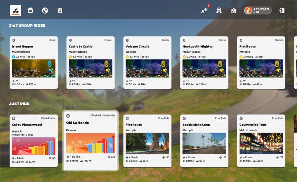
Selecting a climb will bring up a panel showing details and options for that particular climb:
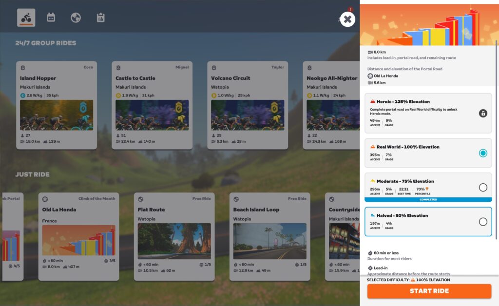
This panel lets you choose a scaled version of the climb. Choose between 50%, 75%, 100%, and 125% (only available once you’ve finished the 100% version). Regardless of scale chosen, everyone rides on the same road.
This same panel also shows your percentile rank for any completed versions of the climb (see 70% percentile on 75% version above). If you’re looking at the current climb of the month, the percentile shown is only for efforts in the current calendar month. This way, each month’s featured climb turns into a month-long game-wide competition, which is a super fun idea. If you’re looking at a climb that isn’t the climb of the month, but just one of the featured climb of the day, the percentile you see is an all-time percentile.
You can also access the Climb Portals by navigating to them during your free ride in Watopia or France. Watopia’s Climb Portal is reachable by turning off of the Volcano Circuit, while France’s Climb Portal is reachable via a left-hand turn toward Mont Saint-Michel when traveling the main loop clockwise:
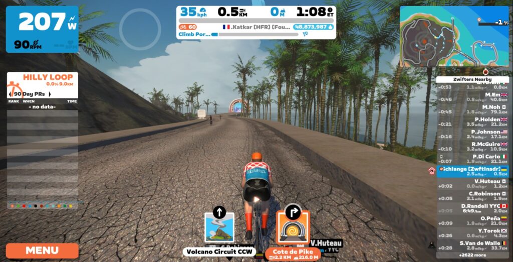
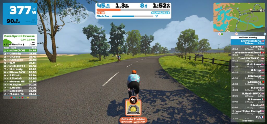
Regardless of how you get there, you ride a short lead-in before going through the Climb Portal, which is labeled with your selected climb. Once you’re through the Portal, your climb begins!
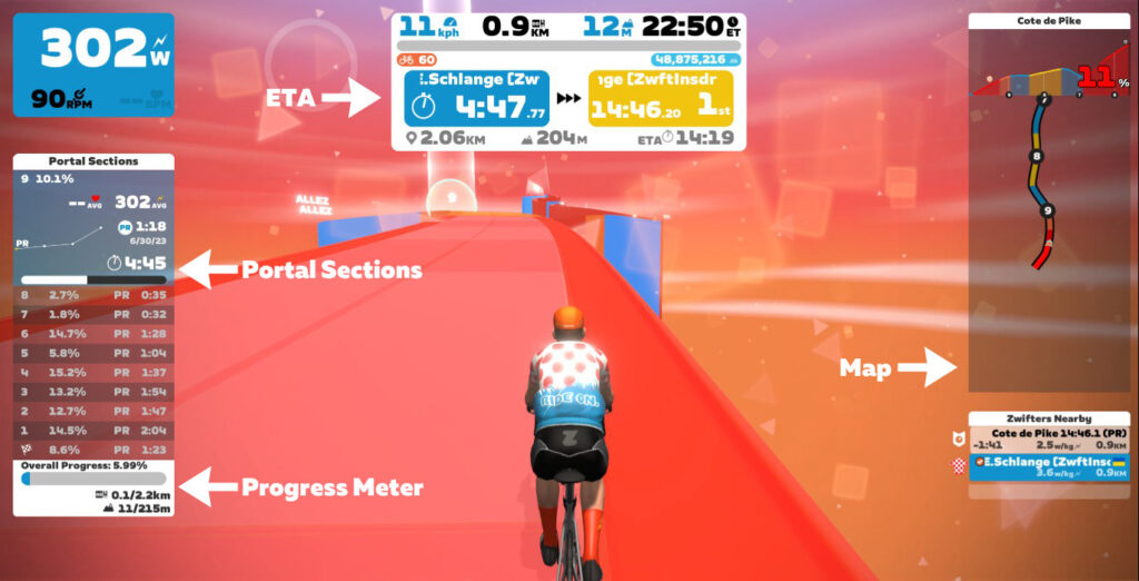
Other riders are visible on the climb, including riders using a different scale that you chose. Icons indicate which scale option every rider is using, and leaderboards are separated by scale factor. If you have HoloReplay enabled, they will also show up if you’ve completed this climb in the past 90 days.
As you climb, the road changes color based on gradient. Floating text and geometric shapes help fill the air and give you a feeling of movement, while the 10 equidistant portal section arches give you a goal up the road to work toward.
Once you reach the top, a summary of your climb will show on screen as you ride the small ring road that loops you around to start your descent. Ride through the finishing arch and begin your descent, and the environment changes. While descending, the sky and road turn to cooler colors, encouraging you to spin those legs out as you enjoy the descent and the animated constellations above.
Ride through the Portal at the bottom of your descent and you’ll find yourself back in your starting world.
Important note: if you ride a 50% or 75% scaled version of your climb during an activity, your entire activity will be tagged as “gamified,” and all Strava segments will be excluded. So if you want your activity to match with Strava segments, don’t mix in a scaled climb portal effort!
Complete List of Portal Climbs
The Climb Portal uses a growing library of uphill challenges! See the full list of Portal climbs below (click a climb for details):
| Climb Title | Length | Elev | Gradient |
|---|---|---|---|
| Bealach na Bà | 9km | 632m | 7% |
| Cauberg | 0.8km | 57m | 7.1% |
| Cheddar Gorge | 4.7km | 171m | 3.6% |
| Cipressa | 6.4km | 228m | 3.5% |
| Col d’Aspin | 13.54km | 807m | 5.8% |
| Col de la Couillole | 18.3km | 1209m | 6.6% |
| Col de la Croix Saint-Robert | 5.7km | 346m | 6.1% |
| Col de la Madeleine | 14.3km | 1118m | 7.8% |
| Col de la Madone | 16.3km | 902m | 5.5% |
| Col de Peyresourde (Avajan) | 8.3km | 559m | 6.7% |
| Col des Aravis | 5.2km | 273m | 5.1% |
| Col du Galibier (Lautaret) | 10.3km | 539m | 5.2% |
| Col du Platzerwasel | 7.82km | 592m | 7.3% |
| Col du Rosier | 5km | 222m | 4.5% |
| Col du Tourmalet | 17.2km | 1213m | 6.9% |
| Coll d'Ordino | 10.3km | 511m | 5% |
| Cote de Domancy | 2.97km | 240m | 7.9% |
| Côte de La Redoute | 1.5km | 153m | 10.2% |
| Cote de Pike | 2.17km | 215m | 9% |
| Cote de Trebiac | 4.6km | 207m | 4.2% |
| Côte des Forche | 3km | 148m | 4.9% |
| Crow Road | 7km | 251m | 3.58% |
| Gotthard Pass | 14.4km | 909m | 6.3% |
| Hardknott Pass | 2.7km | 306m | 11.5% |
| Hautacam | 12.7km | 1029m | 8.1% |
| Isola 2000 | 18.9km | 1145m | 5.9% |
| La Laguna Negra | 9.1km | 510m | 5.6% |
| La Super Planche des Belles Filles | 8.6km | 602m | 7% |
| La Turbie + Col d'Eze | 15.2km | 616m | 3.1% |
| Lagos de Covadonga | 14.5km | 976m | 6.7% |
| Montée du Chinaillon | 8.1km | 353m | 4.4% |
| Mt Fuji | 25.6km | 1218m | 4.7% |
| Mt. Hamilton | 31.3km | 1259m | 3.5% |
| Mûr de Bretagne | 1.96km | 129m | 6.6% |
| Norton Summit | 8.7km | 363m | 4% |
| Old La Honda | 5.6km | 396m | 7.1% |
| Old Willunga Hill | 4km | 252m | 6.3% |
| Oude Kwaremont | 1.5km | 64m | 4.3% |
| Pas de Peyrol/Puy Mary | 10.2km | 603m | 5.9% |
| Pla d'Adet | 12.1km | 847m | 6.9% |
| Poggio | 4.3km | 136m | 3.2% |
| Puy de Dome | 12.96km | 913m | 7% |
| Rocacorba | 11.8km | 756m | 6.4% |
| Trollstigen | 12.4km | 784m | 6.3% |
Climb Portal Schedule
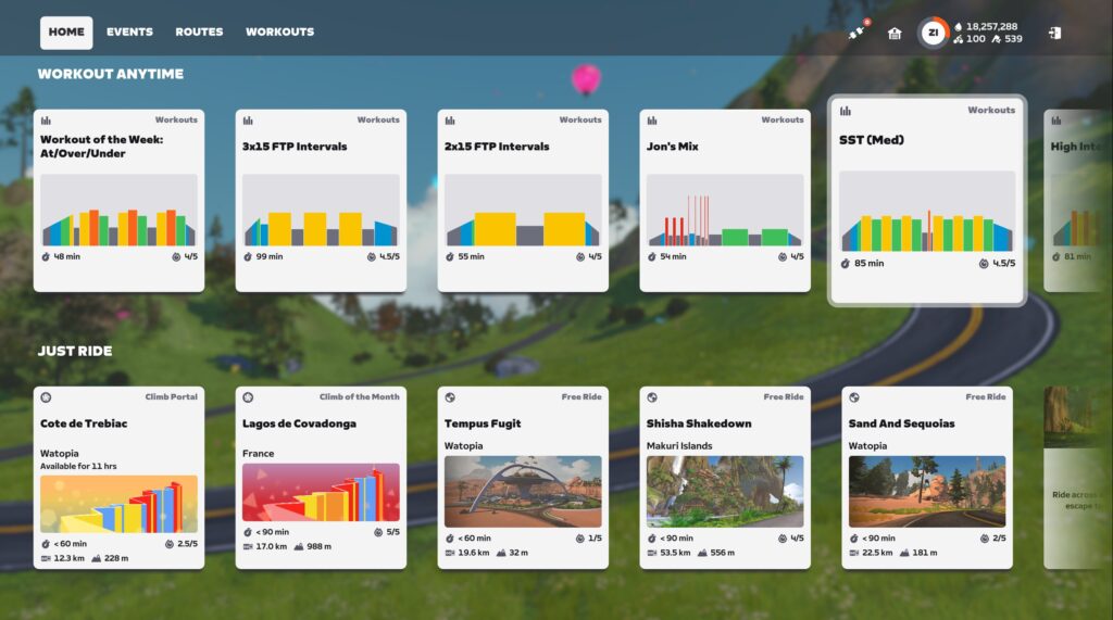
While the library contains many climbs, Zwifters can only access two climbs one any given day. The “climb of the month” is hosted in France, while the day’s featured climb rotates every few days and is hosted in Watopia.
You can access these two climbs easily, from the bottom of the Zwift homescreen under “Just Ride”:
Improvement Ideas
We wouldn’t be true Zwifters if we didn’t have at least three ideas how Zwift could improve a just-released feature. So here are nine:
- More useful maps: the climb profile and overhead views only show nearby portions of the climb. We’d like to be able to click and zoom out to see the full climb.
- Different background sounds: the ambient background sounds while climbing are… odd. Too somber, too heavy, for our taste. That said, we usually ride with sounds off, so this isn’t a big deal.
- Smarter Portal Sections: the “portal sections” seem programmatically generated, just breaking the climb into 10 equidistant sections. This makes adding new climbs easy, but it sure would feel a bit fancier if the sections broke the climb into logical sections at key turns or gradient changes.
- Achievements: there are no achievement badges for portal climbs at this time, which seems like a big miss. We’d love to see smart badges that count how many times you’ve finished each portal climb.
- Companion Leaderboards: we have Leaderboards in Companion now. These should include portal Climbs! (Note: Zwift Insider has collaborated with Veloviewer to create leaderboards for the Climb Portal. Read more here >)
- Enable Fan View and Teleporting: currently you can’t fan view or teleport to a rider who is on a Portal climb. That seems a bit silly.
- Better preview map/graphic from the homescreen. When you click the featured climb from the homescreen, the preview window doesn’t show the selected climb graphically in any way (not an overhead view or an elevation profile).
Strava+VeloViewer Leaderboards
If you start a portal climb from France, your Strava data will show you as climbing it attached to Zwift’s France map (which is based on the French island of New Caledonia for Strava GPS positioning). Start the same climb from Watopia and your Strava data will show you riding in Vanikoro, in the Solomon Islands (where Watopia is located for the purpose of Strava GPS positioning).
This means we’ll have to create two Strava segments for each climb: one for starting in Watopia, the other for starting in France. That means two leaderboards for each climb.
Example: here’s a Strava segment for Côte de Pike in Watopia, and here’s the France version.
Zwift Insider has collaborated with Veloviewer to create leaderboards for the Climb Portal. These leaderboards utilize your fastest time up each climb, regardless of whether you rode it in Watopia, France or both. Read more here >
Your Thoughts
Tried Climb Portal yet? Share your thoughts below!
