“Roule Ma Poule” Route Details (France)

Released with Zwift’s France map for the first-ever Virtual Tour de France, Roule Ma Poule is essentially the reverse version of the Casse-Pattes route, covering the full outer loop in a counter-clockwise direction with a different start/finish location atop the Petit KOM.
Released with Zwift’s France map for the first-ever Virtual Tour de France, Roule Ma Poule is essentially the reverse version of the Casse-Pattes route, covering the full outer loop in a counter-clockwise direction with a different start/finish location atop the Petit KOM.
Route Basics
Length: 23 km (14.3 miles)
Elevation: 155m (509‘)
+3.1km (1.9 miles) lead-in with 108m (354‘) elevation
Map: France
ZIMetrics
Rating: 14.2/100 🛈
Time Estimates 🛈
lead-in + first lap
4 W/kg: 40 minutes
3 W/kg: 45 minutes
2 W/kg: 56 minutes
Start & Finish
Loop begins and ends at Petit KOM arch. Lead-in from start pens/spawn point is significant, with some climbing (see Strava segment below).
Format: Loop
Ride Achievement Badge: 460 XP
Run Achievement Badge: none
Strava Segments
Bike Selection
This route is very flat overall. Your fastest times will come from an aero setup!
Route Description
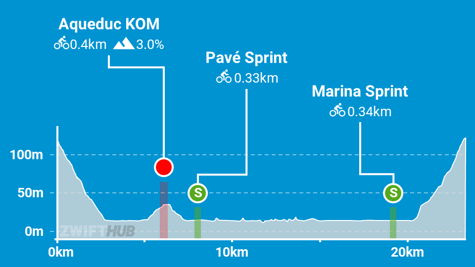
Route profile by ZwiftHub – the place to plan and track your route achievements!
We begin with a significant lead-in climb traveling east from the start pens up to the Petit KOM banner. This is a big climb right out of the gate, and in a race it will create a key selection.
Once you cross the banner the official loop begins, starting with a zigzag descent of the Petit KOM soon followed by the short Aqueduc KOM. Enjoy your ride through the french countryside, hitting the cobbled Pavé Sprint, riding past the field of sunflowers and through the tunnel of trees. Then it’s past the sites of the Needle and Arch, Mont Saint-Michel, and the lighthouse, into the marina and onto the Marina Sprint.
Only a few kilometers left at this point – but it’s all uphill, climbing back up to the Petit KOM banner to finish your lap!
About the name: “Roule Ma Poule” is a colloquial French expression that means “let’s roll” but has a cute ring to it as “Poule” means “hen”. “Ma poule” is also an expression French people may use for their closest friends (in a funny way). This route’s name and most of the names on Zwift’s France map have French cultural influences and were suggested by Laurent Janneau, VP of Brand & Communications at Zwift.