“Surrey Hills” Route Details (London)

London’s “Surrey Hills” route takes you on a complete tour of all the climbs on the London course, riding over each pass in both directions. Since the route keeps you almost entirely off of flat ground, you get a lot of climbing done in just over 44km.
London’s “Surrey Hills” route takes you on a complete tour of all the climbs on the London course, riding over each pass in both directions. Since the route keeps you almost entirely off of flat ground, you get a lot of climbing done in just over 44km.
Route Basics
Length: 39.2 km (24.4 miles)
Elevation: 837m (2,746‘)
+5.1km (3.2 miles) lead-in with 149m (489‘) elevation
Map: London
ZIMetrics
Rating: 30.2/100 🛈
Time Estimates 🛈
lead-in + first lap
4 W/kg: 80 minutes
3 W/kg: 91 minutes
2 W/kg: 120 minutes
Start & Finish
This route's official start/end point is the KOM banner atop the Fox Hill climb. That means you'll have a lead-in of approximately 5km before the route actually starts, and that lead-in includes a climb up Fox Hill!
We’ve created two Strava segments, one for the “event version” (which begins at the start pens) and one which covers only the official route, beginning and ending at the Fox Hill KOM banner after the tough lead-in.
Format: Loop
Ride Achievement Badge: 820 XP
Run Achievement Badge: none
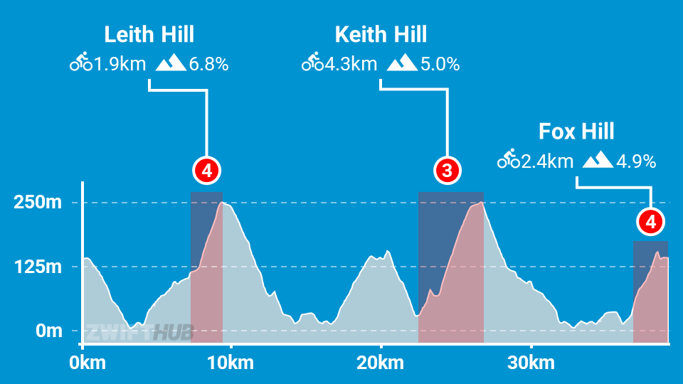
Leaderboard Segments |
| Fox Hill KOM (2.4km, 4.3%) |
| Leith Hill KOM (1.9km, 7%) |
| Keith Hill KOM (4.3km, 5%) |
Strava Segments
BestBikeSplit Model
Estimate ride time, IF and TSS, plan your power, and more!
Route Description
Route profile by ZwiftHub – the place to plan and track your route achievements!
Interestingly, this route begins at a different spawn point than other London routes, facing in what is typically the reverse direction. This bypasses the usual flat London start so you can get climbing quickly – let the suffering begin!
Once you’re in the Surrey Hills, you will continue to ride this route, never going back into the city or crossing the start/finish banner.
You’ll ride up 4 timed KOM climbs on this route. First Fox Hill for the lead-in, then the route begins atop Fox/Box. Next you’ll climb Leith hill – the longest climb of the day.
One weird thing about how this route works is it dumps you onto the Box Hill KOM after the start line, which means you won’t get on the Box Hill leaderboard in Zwift. But you will climb (almost) all of it!
Then it’s on to Keith Hill, then one final go up Fox Hill. The route ends at the KOM banner atop Fox/Box.