
“The London Pretzel” Route Details (London)

Animated map provided by ZwiftHacks
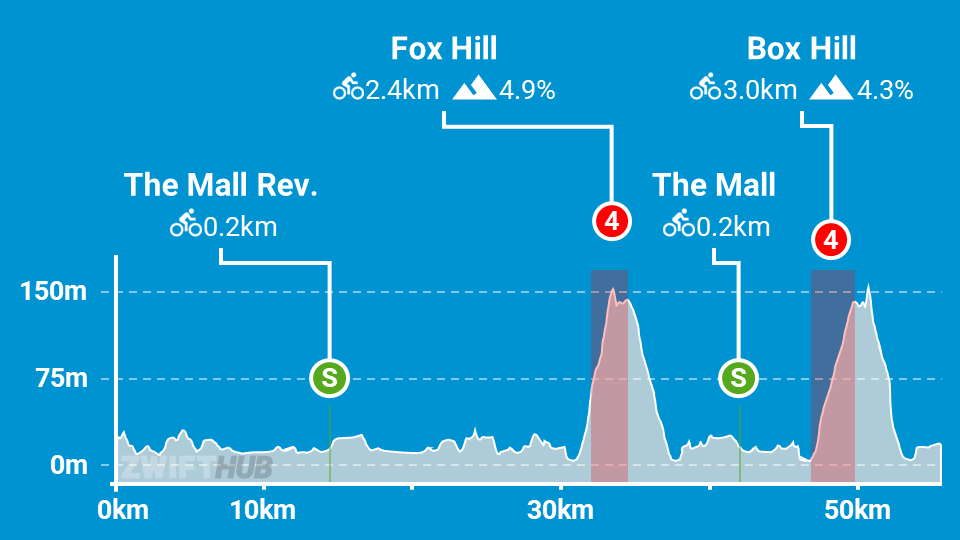
At the time of its release, the “London Pretzel” route was the only route covering all London roads. In fact, it covered them all in both directions. The route leaves off newer additions to the London course, but it’s still a fun one if you’re looking for a longer ride with a mix of flat efforts broken up by two decent climb sections.
Route Basics
Length: 55.7 km (34.6 miles)
Elevation: 571m (1,873′)
+0.6km (0.4 miles) lead-in with 4m (13′) elevation
Map: London
ZIMetrics
Rating: 29.2/100 🛈
Time Estimates 🛈
lead-in + first lap
4 W/kg: 84 minutes
3 W/kg: 94 minutes
2 W/kg: 116 minutes
Start & Finish
Format: Loop
Ride Achievement Badge: 1100 XP
Run Achievement Badge: none
Leaderboard Segments |
| The Mall Sprint Reverse (0.2km, 1.1%) |
| Fox Hill KOM (2.4km, 4.3%) |
| Box Hill KOM (3km, 4.4%) |
Strava Segments
BestBikeSplit Model
Estimate ride time, IF and TSS, plan your power, and more!
Hi Eric,
the elevation is off, Zwift gave me 471m today, incl. lead-in
Best,
Stefan
I just crossed the line with the little lead in at 56.0km and 481 m elevation.
The elevation is about 1550 ft
climbing is just a bit shorter. Just shy of 500m
Rode 60.6km 503m, as a solo meet up no badge. Making ticket and ending subscription until confirmed as fixed.
Strava confirmed
https://strava.app.link/tCbBh99V1db
My bad badge recieved once before: ( my bad!
You were going to end your subscription because you didn’t get a badge?
I hope you had a good cry.
56.2 km and 475 m to complete challenge today
I tried to do this badge last week but gave up after 71k had elapsed without completing the ride. I don’t believe that the distance quoted here is up to date as there are other people who have had an experience similar to mine. I don’t understand why riders who are completing a badge cannot see, on screen, how far they need to go to complete the ride. Maybe I expect too much for 13 quid a month.
This feature is now in there, where you can see how much is left for the course
Hi Carl- Im signed up for the Garmin Never Stop Cycling 4-stage challenge. This long ride doesn’t say anything about bike type recommended. Is this London loop all road bike or would I need to switch to mountain bike at all? Some routes clearly explain what is needed but I can’t find that info on this loop. Thanks
All of London’s routes are road bike. London loop, not sure what’s the best road bike to use, aero vs pure road. Maybe an aero with lighter wheels (not sure what your wheel options are)?
Watopia has a few courses where you should switch between road and MTB.
And some of the Makuri Island (excluding the new Neokyo routes) could use a MTB as well. All other worlds (Innsbruck, London, Richmond, and most of Watopia) are purely road (or aero bike)
Route is all tarmac/pavement expect the wood in the tube stations and tracks. Flat/rolling first two thirds then. Hilly last third. More balanced bike setup, so not losing too much time and less work in first 2/3, but climbs well in last third is best. As Fox is steeper and Box just hurts towards the end ride.
#tronlife
Only got 481 m of elevation gain
So I got here by clicking on e-fondo Asheville….https://www.granfondonationalseries.com/2024-efondo-series where is that route?
This is the route. The way they present it on that URL is rather confusing, since they’re giving each event a real-world name. But they’re using existing Zwift routes.
Not sure what’s going on. I did this route yesterday and I got the route badge, finishing it with about 580m of elevation after riding 56km. This page says it should be 475m and Zwifterbikes says it should 531m, while the companion app says it should be 576m.
Weird. I think Zwift must have modified something in London that changed the elevation for this route. Some time in the last 2 years.
Because check out this video – Zim finishes the race at 56km and 478m of climbing! https://www.youtube.com/watch?v=fdTaqpqUKeI
But newer videos show numbers matching yours.
I just updated the stats for the route, so it should reflect what’s actually in game now.
Hi Eric, thanks for checking. You must be right. I had a couple of saved pictures from my ride and compared them to the same points on Zim’s video. At 4.2km into the ride, he shows 32m climbing, whereas I show 43m. At 42.3km into the ride, he shows 301m of climbing and I show 375m. So something has changed.
the leaderboard section is missing a sprint