“Champs-Élysées” Route Details (Paris)

As the final stage of first-ever Virtual Tour de France, Zwift’s Champs-Élysées route was designed to mimic what may be the most recognizable road in the world: the Avenue des Champs-Élysées in Paris. While the avenue is known for its theaters, cafés, luxury shops, and annual Bastille Day parade, it’s best-known among cyclists as the finish of the Tour de France!
As the final stage of first-ever Virtual Tour de France, Zwift’s Champs-Élysées route was designed to mimic what may be the most recognizable road in the world: the Avenue des Champs-Élysées in Paris. While the avenue is known for its theaters, cafés, luxury shops, and annual Bastille Day parade, it’s best-known among cyclists as the finish of the Tour de France!
Route Basics
Length: 6.6 km (4.1 miles)
Elevation: 39m (128‘)
+3.1km (1.9 miles) lead-in with 13m (43‘) elevation
Map: Paris
ZIMetrics
Rating: 4.6/100 🛈
Time Estimates 🛈
lead-in + first lap
4 W/kg: 14 minutes
3 W/kg: 15 minutes
2 W/kg: 18 minutes
Start & Finish
Laps begin and end at lap banner. There is a significant lead-in from the start pens/spawn point.
Format: Loop
Ride Achievement Badge: 130 XP
Run Achievement Badge: 130 XP
Leaderboard Segments |
| Lutece Sprint (0.15km, 3.5%) |
| Champs-Élysées (6.6km, 0%) |
Strava Segments
Champs-Élysées
Champs-Élysées Lead-In from Start Pens
Champs-Élysées Run
Bike Selection
This route is quite flat overall. Your fastest times will come from an aero setup!
Route Description
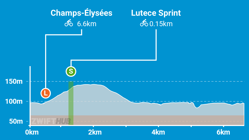
Route profile by ZwiftHub – the place to plan and track your route achievements!
Avenue des Champs-Élysées runs between the Place de la Concorde (to the east) and the Place de l’Étoile (to the west, where the Arc de Triomphe is located). The official Champs-Élysées finishing circuit loops around the Jardin des Tuileries on the east end, and around the Arc de Triomphe on the west end. You will begin with a lead-in around Jardin des Tuileries. The road around the back of the garden includes a short ramp down and back up – the steepest sections of the circuit. Once you finish your loop around the garden you will soon ride through the start/finish arch, which begins the official circuit.


Note the iconic cobbles under your wheels as you feel the road turn upward – you’re on Montée des Champs Elysées, the 1.3km climb up to the Arc de Triomphe. It’s not a steep climb, but you can expect attacks here every lap when racing. There’s also a sprint point here, which only raises the stakes higher! Once you arrive at Place de l’Étoile the road levels out for a quick turn around the Arc de Triomphe, then it’s time to descend Avenue des Champs-Élysées. Note the Obelisk of Luxor, visible in the distance at the other end of the circuit. You may also glimpse the Eiffel Tower, if you know where to look!